- Searching for Openness in Microsoft’s OOXML and Finding Contradictions
- Knoppix 5.1.1: Now with eye candy
- A Simple Example of Network-Oriented Architecture
- Information Security and Externalities
- Zenwalk 4.2 — There isn’t anything mini about this distro anymore
Google Removed Sensitive Maps Imagery (Apparently)
Published By: Philipp Lenssen on January 18, 2007 - 6:47am
Original Blog Entry Located Here
Filed In: Networking | Security
Original Blog Entry Located Here
Filed In: Networking | Security
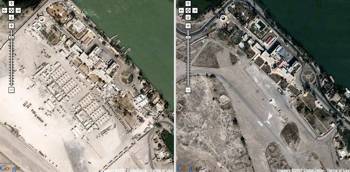
Stefan Geens of the Ogle Earth blog published an impressive piece of digital research that suggests that Google censored some recent satellite imagery in Google Maps/ Google Earth upon government request. What apparently happened is that new satellite imagery from Basra, Iraq, was intentionally replaced with outdated, pre-war imagery, so that it’s of not much help to fighters attacking the US/ British/ ... troops. A UK Telegraph article cites a British military spokesman ...
<
... and Google responds:
<
[Via Googling Google.]
[By Philipp Lenssen | Original post | Comments]
Bookmark/Search this post with:
| | | | | | | |
Sponsored White Paper
Recent Blog Entries
Related Blog Entries
Newsletter
Get these headlines/links in a daily e-mail newsletter.
Sponsored Links
User login
- Create new account
- Request new password
Navigation
Browse archives
| Su | Mo | Tu | We | Th | Fr | Sa |
|---|---|---|---|---|---|---|
| 1 | 2 | 3 | 4 | 5 | 6 | |
| 7 | 8 | 9 | 10 | 11 | 12 | 13 |
| 14 | 15 | 16 | 17 | 18 | 19 | 20 |
| 21 | 22 | 23 | 24 | 25 | 26 | 27 |
| 28 | 29 | 30 | 31 |